English version (Version française à la fin)
Introduction
This is a LibreOffice Calc file which helps you to setup a flight plan, and starts to auto-generate the corresponding navlog. Then the navlog should be completed even more, manually, in order to specify values at the avionics level; such as active/stand-by frequencies of NAV1 and NAV2, ADF, the CDI mode, the Heading (HDG) and the auo-pilot (AP) mode. What I propose is clearly not a revolution as a lot of tools, apps and websites already provide the ability to prepare a flight and generate the correponding navlog.
The problem is first that the free version of these tools is often limited or incomplete, like Mach7 which is available only for France, or AirMate which does not allow to generate/print a navlog from its website and you have to install the mobile version (iOS/ Android) for that.
Features
Secondly instrument navigation is not easy when your are a beginner, so the main goal of this tool is more to guide you in this area. It is a small step ("for Man ...") to understand how a navigation system like the Garmin G1000 works but you still have to know then how to use it concretely and how to configure it once in flight, with the right values and at the right time. I think this (interactive) way of flying is much more immersive and funny than just follow a route with the GPS and stay an observer the whole way.
With this file you can prepare in advance "on paper" those different parameters and when you are in control of your plane in the air you only need to read it and effectively apply the related settings in your navigation system, without having to ask yourself what you have to do or what must be changed, at the risk of making a mistake, of wasting time and therefore getting lost on the way.
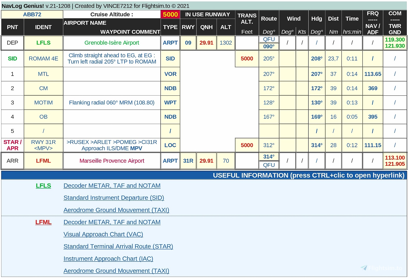
This project file is provided with a sample flight plan and navigation log
for a trip in France between Grenoble-LFLS and Marseille Provence-LFML
with a Diamond DA62 airplane.
The file consists mainly of 2 sheets : FLIGHT PLAN and NAVLOG. I've added 2 extra sheets containing reference data for airports and navaids. This is just to be seen as "nice to have" options : for example airports data allow to show the name of the airport associated with its identifier, and other information like country, city, home website, etc. can be eventually used in later versions. This is the same principle as for navaids data (NDB, VOR, DME, etc.) that can be used to show details about them in the flight plan, but this is not yet applicable in the current version (1.1).
- Sheet 1 : FLIGHT PLAN
This is where you plan your flight by defining a departure and arrival airport, as well as the various waypoints (max. 6). Only cells with a light yellow background color can / should be filled.
Information you have to provide is :- Departure Airport (B5)
- QFU (E5)
- QNH (F5)
- Altitude (G5)
- COM frequence (M5)
- Arrival Airport (B20)
- QFU (E20)
- QNH (F20)
- Altitude (G20)
- COM frequence (M20)
- Turning points
- Identification (B6-B18)
- Type (D6-D18) : list of values : NDB ; VOR ; VOR/DME ; VOR/LOC ; WAYPNT ; VFR
- Course (H6-H18) : this is the theoretical course to follow to connect this point
- Route (I6-I18) : this is the actual heading to follow to connect this point, taking into account mainly the weather conditions and the drift due to the wind (*)
- Distance (J6-J18) : this is the distance with the previous point (nautic miles)
- Time (K6-K18) : this is the time to fly from the previous point (minutes:seconds)
- ADF (L6-L18) : this is the ADF frequence if the point is a non-directional beacon (NDB)
- NAV (M6-M18) : this is the frequence to consider if the point is a VHF omnidirectional Range (VOR, VOR/DME or VOR/LOC)
- Departure Airport (B5)
(*) You have to find or compute yourself data about drift, but some applications do that for you, like Little Navmap. You can also decide to not take into account the drift so you have to set the same values in the Course and Route fields. You will probably have to adjust your heading once in the air except if you fly in NAV autopilot mode since in this case the aircraft does adjustments for you ;-)
Information on airports like in use runways, COM frequencies, altitudes etc. can be found on various places, that's why I also provide a "usefull information" section that will allow you to find that information. The airport identification is an hyperlink that will open a general information page about the airport. Then you have some extra hyperlinks that will give you access to various charts, if they are available for that airport of course. Please note that links are built based on the origin and destination airport identification in cells B5 and B20.
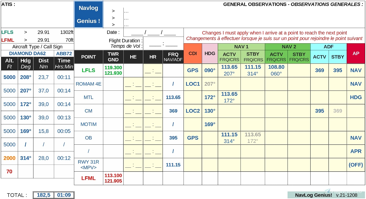
- Sheet 2 : NAVLOG
I will not cover here the why and how of a navigation log but what you have to know (if not already known) is that a navigation log is a tool that you use to guide your preflight planning, and a plan that you execute in flight. The value you obtain from the navigation log is the centralization of all of the information you need in an easy to read, single location.
Luckily the navigation log is pre-filled with the data that was encoded in the first sheet.
This reduces the risk of encoding errors, and you only have to focus on the avionic system and specify its configuration at each step of your trip by indicating the following parameters you need to consider once you have reached the waypoint or close to it, so in other words "what do I have to do now to go to the next waypoint?" :
- In which auto-pilot mode do I have to fly now ? HDG, NAV, APR, ... ?
- What heading do I have to follow ?
- If my next point is a NDB : how ADF must be set ? (if any)
- If my next point is a VOR : how NAV1 and/or NAV2 frequency/course must be set now ?
- In which CDI mode (GPS, LOC1, LOC2) do I have to be ?
Like for the flight plan in sheet 1, data with grey background should not be changed, they are computed from the flight plan. The cells you have to fill in are with light yellow background.
Installation
Download and extract the zip file into the location of you choice. It is simply an .ods (LibreOffice) file, it is not an addon that you install inside the Community folder of MSFS.
Read-only mode
Some people might encounter a warning message when opening the file informing that it is in "read-only" mode. If this is the case for you please check the attributes of the .ods file you've extracted or open the file anyway and save it under another name.
Version française
Introduction
Il s'agit d'un fichier LibreOffice Calc qui vous aide à configurer un plan de vol et commence à générer automatiquement le log de navigation (navlog) correspondant. Ensuite, le navlog doit être complété plus en détail, manuellement, afin de spécifier des valeurs au niveau avionique; telles que les fréquences actives/stand-by de NAV1 et NAV2, celles de l'ADF, le mode CDI, la valeur du Heading (HDG), et le mode de l'auto-pilot (AP). Ce que je propose n'est clairement pas une révolution car beaucoup d'outils, d'applications et de sites web offrent déjà la possibilité de préparer un vol et de générer le navlog correspondant.
Le problème est d'abord que la version gratuite de ces outils est souvent limitée ou incomplète, comme Mach7 qui n'est disponible que pour la France, ou AirMate qui ne permet pas de générer/imprimer un navlog depuis son site internet et il faut installer la version mobile ( iOS/Android) pour cela.
Fonctionnalités
Ensuite la navigation aux instruments n'est pas facile lorsque vous êtes débutant, donc l'objectif principal de cet outil est plus de vous guider dans ce domaine. C'est un petit pas ("pour l'Homme...") de comprendre comment fonctionne un système de navigation comme le Garmin G1000 mais encore faut-il savoir ensuite l'utiliser concrètement et comment le configurer une fois en vol, avec les bonnes valeurs et au bon moment. Je pense que cette façon (interactive) de voler est beaucoup plus immersive et amusante que de simplement suivre un itinéraire avec le GPS et de rester un observateur tout au long du trajet.
Avec ce fichier vous pouvez préparer à l'avance "sur papier" ces différents paramètres et lorsque vous êtes aux commandes de votre avion en vol il vous suffit de le lire et d'appliquer effectivement les réglages associés dans votre système de navigation, sans avoir à vous demander ce que vous devez faire ou ce qu'il faut changer, au risque de se tromper, de perdre du temps et donc de se perdre en chemin.
Ce fichier projet est fourni avec un exemple de plan de vol et de carnet de navigation
pour un trajet en France entre Grenoble/LFQW et MArseille Provence/LFGB
avec un avion Diamond DA62.
Le fichier se compose principalement de 2 feuilles : FLIGHT PLAN et NAVLOG. J'ai ajouté 2 feuilles supplémentaires contenant des données de référence pour les aéroports et les aides à la navigation (navaids). Il s'agit simplement d'options complémentaires; par exemple les données d'aéroports permettent d'afficher le nom de l'aéroport associé à son identification, et d'autres informations telles que le pays, la ville, le site Web personnel, etc. pourront être éventuellement être utilisées dans des versions ultérieures. C'est le même principe que pour les données d'aides à la navigation (NDB, VOR, DME, etc.) qui peuvent être utilisées pour afficher des détails sur ceux-ci dans le plan de vol, mais ce n'est pas encore applicable dans la version actuelle (1.1).
à compléter...
The final word
Le mot de la fin
I hope this will be clear enough and easy to use. Do not hesitate to contact me in case of problems.
J'espère que ce sera assez clair et facile à utiliser. N'hésitez pas à me contacter en cas de problème.
I will answer you as soon as I have the time.
Je vous répondrai dès que j'en ai le temps.
Thanks a lot already for your interest in this tool !
Merci beaucoup déjà pour l'intérêt que vous portez à cet outil !


Vince I just want to Thank You so much for this wonderful NavLog "App"! I can see that there is alot of work put into this!
Do you know if there are any video tutorials or helpfile for it?
Once again, Thanks! 😊
1 years ago
Hello Ernie. Sorry for the late reply. No there is no video or documentation but I can help you in case you need.
11 months ago
Vince7212
ErnieBall
Hi, Thanks for this work. I have a question. Where did you get the ref-navaids file? I made some changes on your project, rewriting it using excel (adapted to my way of flying) and I found that there are some errors in this file.
2 years ago
Hello. Thanks. This file of course can be completed in some ways (allow more waypoints, add detailed SID's or STAR's, etc.) I still have some ideas in my pipeline :)
Data about airports and navdata have been taken from https://ourairports.com/data/
Regards,
2 years ago
Vince7212
jlr91
In the 1 - Flight Plan tab, shouldn't the merged cell (B&C 26) that has LFGB in it also have a hyperlink?
2 years ago
As far as I can see there is a link over there too. Please download version 1.1.3 so that you also have the HDG column in tab NAVLOG.
2 years ago
Vince7212
pgilbr
It appears that you submitted the same file from 11/24, the link is still broken in the ver1.1.2 that I just downloaded.
2 years ago
Hello. Thanks for the remark. I do things a bit too quickly for the moment :) I will check this but my father donwloaded the last version and the links work... strange. I will soon ulpoad a new version 1.1.3 that will contain extra column "HDG" in the navlog part, in which you set the heading value with the HDG knob.
2 years ago
Vince7212
pgilbr